
Maps offer a powerful tool for understanding what's happening over large areas. By putting together the data on whale
sightings from many places up and down the coast, scientists have been able to determine whale migration
patterns, as seen in the map below.
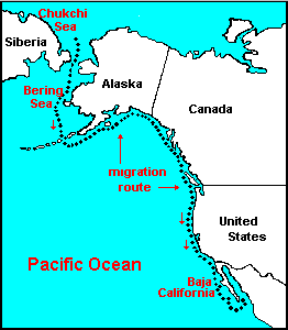 Many whales migrate south for the winter, especially those that feed in northern waters. For grey
whales, the journey begins in the frigid waters of the Chukchi and Bering Seas between Alaska and Siberia.
The whales spends the summer and the beginning of fall in the Arctic before heading south.
Many whales migrate south for the winter, especially those that feed in northern waters. For grey
whales, the journey begins in the frigid waters of the Chukchi and Bering Seas between Alaska and Siberia.
The whales spends the summer and the beginning of fall in the Arctic before heading south.
Around mid to late fall, the whales start their 5000-mile journey south to Baja
California. The grey whales head south for two reasons: shelter and breeding.
You can check out sightings made in Santa Barbara or add your own sighting using the
The Channel Islands Marine Sanctuary Marine Mammal Sightings Database. Another
great source for grey whale migration data is available at Grey Whales Count.
Back to Data Collection
|